The Encyclopedia of Cleveland History

|
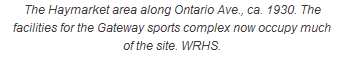
MAYFIELD VILLAGE - The Encyclopedia of Cleveland HistoryMAYFIELD VILLAGE, originally part of Mayfield Twp., incorporated on 21 March 1921. It is located east of Cleveland, bounded by GATES MILLS on the east, MAYFIELD HEIGHTS on the south, HIGHLAND HEIGHTS on the west, and Willoughby Hills in Lake County on the north. It occupies just over 4 sq. mi. Settlement in the area began in 1805, when several families migrated from Ontario County, NY. Mayfield Twp., formed on 14 June 1819 from Chagrin Twp., also included the modern communities of Gates Mills, Highland Hts., and Mayfield Hts., and a portion of LYNDHURST. In 1920 a special election divided the township into 4 villages. An area known as Mayfield Centre formed at the present intersection of SOM Center and Wilson Mills roads; a sawmill located north of there. At the beginning of the 20th century, the area was still principally occupied with farming, dairying, and orchard-growing (see AGRICULTURE). ZONING in 1935 secured the area's residential character: the population gradually increased from 1,977 in 1960, to 3,548 in 1970, then decreased slightly to 3,462 in 1990 and 3,435 in 2000. Mayfield Village belongs to the Mayfield City School District. It hosts the district's high school as well as one of the 4 regional libraries of the CUYAHOGA COUNTY PUBLIC LIBRARY SYSTEM (CCPL). Recreational facilities include a golf course and a portion of the North Chagrin Reservation of the CLEVELAND METROPARKS. Last Modified: 22 Jun 2003 02:32:31 PM
This site maintained by Case Western Reserve University
|