The Encyclopedia of Cleveland History

|
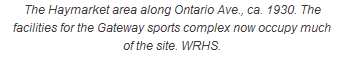
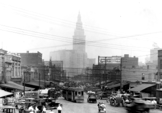
BUCKEYE-SHAKER SQUARE - The Encyclopedia of Cleveland HistoryBuckeye-Shaker Square is a neighborhood and planning district in Cleveland that is bounded by Shaker Heights to the north and east, Abell and Imperial Avenues to the south, and E. 116th Street to the west. Buckeye-Shaker Square is home to SHAKER SQUARE and the LARCHMERE arts and antiques district as well as one of the city's most accessible districts by mass transit and bicycle. Although Buckeye-Shaker is one of Cleveland's most compact planning districts, it has a rather fragmented identity, as its hyphenated name suggests. Shaker Boulevard and the RTA tracks divide the district in half. Furthermore, Buckeye-Shaker is composed of several distinct neighborhoods within the planning district; the upper Buckeye neighborhood, the Cleveland portion of the LUDLOW neighborhood; Larchmere; and Shaker Square. The district's identity is further fragmented by having multiple wards, school districts, and development corporations. It also shares a meandering border with SHAKER HEIGHTS. Despite this segmentation, Shaker Square has served as a portal for intermingling among residents of these different neighborhoods, and for nearby suburbs. The land that now comprises Buckeye-Shaker Square was originally part of the NEWBURGH Township. By the 1870s, a number of farmers developed homestead farms in the area. Around 1910, large subdivisions were laid out and sold in un-built lots in the present-day Larchmere neighborhood (northwest of present-day Shaker Square). Homes consisted of single family houses and "Cleveland doubles. " This housing was generally populated by ITALIANS, and HUNGARIANS. There were also notable GERMANS and CZECHS population. The 1920s ushered in a new decade of intensive development near present-day Shaker Square that shaped much of the contemporary geography of Buckeye-Shaker Square. In 1920, the VAN SWERINGENS † completed the SHAKER HEIGHTS RAPID TRANSIT (originally the Cleveland Interurban Railroad), which provided service on Moreland (later Van Aiken) and Shaker Boulevards to PUBLIC SQUARE. The construction of the rapid allowed the area to become one of the easiest commutes to downtown, but also splintered the area in half, a physical and mental divide that exists to this day. By the 1930s, a number of apartment complexes lined Moreland and Shaker Boulevards. Buckeye-Shaker Square's high density also has its origins in the 1920s. In 1922, JOSIAH KIRBY began building the luxurious MORELAND COURTS apartments (later condominiums) north of Shaker Blvd. and to the east of present-day Shaker Square. Moreland Courts was finished several years later by the VAN SWERINGEN brothers. In 1929, Shaker Square, which has been designated as the second oldest planned, shopping district in the United States, was completed. Aerial images of Buckeye-Shaker Square suggest that development slowed after the nation entered Great Depression, claiming the Van Sweringen empire among its casualties. Despite this, The COLONY THEATER (later Shaker Square Cinemas) was completed on Shaker Square in 1937. The construction of high-density apartments in the Shaker Square vicinity during the 1940s further added population to district. Apartment construction continued along Shaker Blvd. until about 1960, by which time most of the district's contemporary physical appearance and infrastructure had been built. Buckeye-Shaker Square faced a new threat during the 1960s, in the form of a proposed freeway which was to stretch from E.55th Street in Cleveland to Pepper Pike to the east. The proposed I-290's path would have cut across the neighborhood along Larchmere Boulevard. Opposition from the Stokes administration ( Cleveland Mayor CARL B. STOKES † was a Buckeye-Shaker Square resident whose home appears to have been on the destruction path) , Shaker Heights, and Cleveland Heights helped pressure Governor James Rhodes to cancel plans for the freeway. Efforts to preserve nearby Shaker Lakes and establish a nature center were also pivotal to blocking the freeway project.The latter half of the twentieth century was also marked by demographic change. By 1960, the African American community in nearby Mt. Pleasant begin to expand into the southern reaches of the of Buckeye neighborhood and along Ludlow Road in Buckeye-Shaker Square. African Americans, however, were unable to move north of Shaker Boulevard in significant numbers until the 1970s. The appearance of African American families in the area unsettled many whites who held racist attitudes towards minorities and feared neighborhood integration. In 1956, a house belonging to an African American couple near Ludlow road (just southeast of Shaker Square) was bombed before they could move in. Residents in the Cleveland and Shaker Heights sections of this community formed the LUDLOW COMMUNITY ASSN. in 1957 (incorporated 1959) to quell racial tensions in their neighborhood. The Ludlow Community Association gained national attention for efforts at promoting a stable integrated community. In 1960, the CLEVELAND FOUNDATION gave the Ludlow Community Association a $7,500 grant to establish a real estate clearinghouse. The resulting Ludlow Co. then gave financial incentives to whites willing to move into integrated neighborhoods, in order to keep the community racially mixed. While this segment of Buckeye-Shaker Square's demographics transitioned slowly, it proceeded far more rapidly in the Buckeye neighborhood. By 1970, census tract south of Buckeye Road went from 28.5 percent to 60 percent African American. By 2000, the Buckeye community was over 90 percent African American., In 1976, Shaker Square was listed in the National Register of Historic Places and the Friends of Shaker Square was formed. Friends of Shaker Square later became the Shaker Square Development Corporation, whose goal was to promote the preservation of the shopping center's original character. The organization provided a tenant referral, a neighborhood security program, and was active in supporting public improvements on Shaker Square. It also published a neighborhood newspaper, The Connection. As of 2010, Buckeye-Shaker Square was home to a diverse population of different socio-economic backgrounds. The district is also home wide variety of stores and architectural styles. Larchmere has become an arts and antiques shopping destination while Shaker Square has maintained its reputation as one of the most desired neighborhoods in Cleveland to live and dine in. Last Modified: 01 Apr 2013 10:59:29 AM
This site maintained by Case Western Reserve University
|